![[A picture of earthquake-moved railroad tracks]](../../../../img/earthquakes/Railroad.gif)
 (576K) Earthquake Picture- Walking the line- Click for bigger version
An earthquake is the shaking of the earth caused by pieces of the crust of the Earth that suddenly shift. The crust, the thin outer layer, is mostly cold and brittle rock compared to the hot rock deeper inside. This crust is full of large and small cracks called faults. Although these faults can be hundreds of miles long, usually you cannot see the cracks because they are buried deep underground and because the pieces of crust are compressed together very tightly. The powerful forces that compress these crustal pieces also cause them to move very slowly. When two pieces that are next to each other get pushed in different directions, they will stick together for a long time (many years), but eventually the forces pushing on them will force them to break apart and move. This sudden shift in the rock shakes all of the rock around it. These vibrations, called seismic waves, travel outward in all directions and are called an earthquake. The underground location where the rock first broke apart or shifted is called the focus of the earthquake.
![[a
diagram of plate movement]](../../../../img/earthquakes/PlateTectonics.gif)
![[a diagram
of the epicenter and transmission of force of an earthquake]](../../../../img/earthquakes/Epicenter.gif)
![[a picture of an ancient Chinese seismograph]](../../../../img/earthquakes/CSeismograph.gif) Chinese Seismograph vase
courtesy of National Geographic magazine
Chinese Seismograph vase
courtesy of National Geographic magazine
![[a picture of a modern seismograph]](../../../../img/earthquakes/MkSeismograph.gif) Modern Seismograph
Modern Seismograph
Today geologists measure earthquake waves with a seismograph.
A typical seismograph works in a very simple way:
A heavy weight is fastened to a horizontal rod as shown in the diagram. This rod hangs from a pole ( and is free to swing from side to side when
the ground shakes. At the other end of the rod (away from the pole) is an ink pen, and directly underneath the pen is a piece of paper rolled around a
cylinder . This cylinder rotates so that the pen continuously draws an ink line along the moving paper. If the ground does not move, the rod does not
swing, and the pen stays in place, so the ink line is smooth and straight.
If the ground shakes, however, the row swings and so the pen draws a zig-zag line as the paper turns. The stronger the shaking, the sharper the zig-zags.
This zig-zag picture made on the paper roll is called a seismogram.
Do you know how easy it is to build a seismograph? (Click on the highlighted word to give it a try.)
Since every earthquake is a little different, each quake makes its own unique zig-zag pattern (seismogram) on paper. Here are some sample seismograms from an earthquake:
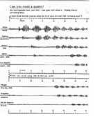
Most seismograms look similar to the ones above -- maybe a bit confusing at first. Reading a seismogram does not have to be complicated, however. If you know what to look for, you can pick out the important parts in a seismogram and get some very valuable information.
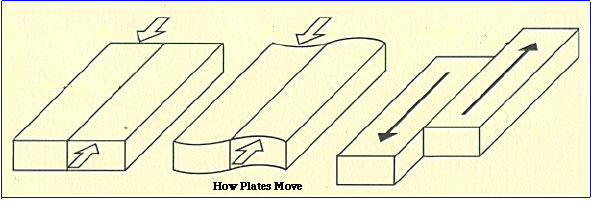 Moving Plates
Seismic waves start where a large section of rock suddenly shifts. This rock movement creates at least three types of waves:
Moving Plates
Seismic waves start where a large section of rock suddenly shifts. This rock movement creates at least three types of waves:
![]() Primary (P)waves : Pressure waves caused when rock is pushed or pulled forward or backward. Primary waves, the fastest wave sent out by an earthquake, travel down into the earth rather than along the surface.(Remember: P waves - primary,p ressure, push-and-pull
Primary (P)waves : Pressure waves caused when rock is pushed or pulled forward or backward. Primary waves, the fastest wave sent out by an earthquake, travel down into the earth rather than along the surface.(Remember: P waves - primary,p ressure, push-and-pull
![]() Secondary (S) waves : Shear waves caused when rock is shaken or whipped from side-to-side, like the wavy motion of a slithery snake. Secondary waves, the second-fastest wave sent out by an earthquake, travel down into the earth rather than along the surface. (Remember: S waves - second, shear, side-to-side)
Secondary (S) waves : Shear waves caused when rock is shaken or whipped from side-to-side, like the wavy motion of a slithery snake. Secondary waves, the second-fastest wave sent out by an earthquake, travel down into the earth rather than along the surface. (Remember: S waves - second, shear, side-to-side)
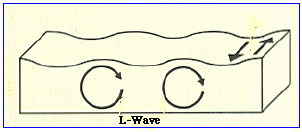 Surface (L) waves : Up-and-down (rolling) or side-to-side motion of the earth surface. Surface waves, the slowest earthquake waves, travel along the surface of the earth rather than down into the earth. Although they are the slowest of all earthquake waves, L waves usually cause more damage to society than P or S waves. L waves were named after a geologist who studied them. ( Remember: L waves are always the last to arrive.
Every earthquake creates these three kinds of waves. P and S travel downward into the earth, and L waves travel along the top of the crust.
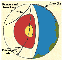
At the instant an earthquake occurs, P, S and L waves immediately begin racing outward in all directions, losing energy as they spread out. If they encounter no interference, P and S waves for a large earthquake should quickly travel all of the way through the middle of the earth and faintly arrive on the opposite side of the globe. An earthquake at the south pole, for eample, would shake the north pole in less than half an hour (though the vibrations would be very weak). This is what P and S wavesshould do. However, the P and S waves do not always make it to the opposite side. Why not? You can find out later in the activity Shadows from the Core.
Suppose you owned a seismograph. One day it suddenly starts measuring earthquake waves that came from somewhere else. Using only your own seismograph, can you determine where that "somewhere else" was located? You cannot determine exactly where it was located, but you can determine how far away from you it was. How?
Because S waves travel slower than P waves, they always arrive at locations around the world after P waves arrive. This may sound simple, but it is also very useful. How much does the S wave fall behind the P wave? If your seismograph can tell you how many minutes the S wave is behind, you can tell how far they had to travel to get that many minutes behind. Try this in the activity Race of the Waves.
Some quakes hit busy cities or small villages where somebody can tell you about it, but even if a quake hits far away from people, it sends out waves to all parts of the globe. You can use your seismograph to record these waves and determine how far away the epicenter is from your seismogram. To pinpoint the exact location of a quake, you need at least three seismographs. Why do you think two seismographs are not enough?
Be a geologist again and try locating the epicenter of an earthquake. The activity Can You Read a Quake? has seven different seismograms that all came from the same earthquake. This activity did not tell you where the earthquake actually hit. Can you use these seismograms to pinpoint the actual epicenter? Try this in the activity Where did it hit?
If you had your own seismograph at home, would you be able to detect a large earthquake that occurred in Mexico City? Rome? Nairobi? Moscow? Tokyo? Bangkok? Since all large earthquakes send P and S seismic waves through the interior of the earth, you should be able to receive these waves from every part of the globe. Many years ago, however, geologists noticed something strange. Waves that did not venture too deep could travel a few thousand kilometers through underground rock and arrive back at the surface without any problems. But the waves that traveled farthest, those that had to pass through the core of the earth, seemed to disappear before they reached the other side. Could the waves simply die out on the longest journeys? No; geologists were sure that the waves had plenty of energy to make it to the other side. What was the problem? What do you think would explain the disappeartin waves? To find out, try the activity Shadows from the Core.
Predicting earthquakes had been one of the most interesting and difficult challenges a scientist can attempt. For many decades, San Francisco had waited for the "big one" to hit. Then in the fall of 1989, as thousands of people drove home from work on bustling freeways, the earth began to rumble. Within minutes a city of several million people was shaken nearly to disaster. Destroyed homes...collapsed bridges...fires...ambulances.... Was this the quake they had waited for? Could somebody have accurately predicted it? Could somebody have actually stopped it?
In 1995, shortly before sunrise, the city of Kobe, Japan was violently rocked awake by a slightly larger earthquake. The destruction was far worse than in San Francisco. Why was it worse? Could this destruction have been prevented somehow?
These are troubling questions with no easy answers. People around the world have often claimed to accurately predict earthquakes by studying things such as animal behavior or movements of the planets. No method has been proven to be consistently successful, however.
Most geologists do believe that we will someday be able to predict many quakes. Some also believe that we will be able to prevent some quakes from occurring. Should we try? What are the risks? What are the benefits? To give these questions more thought, try joining a geology research team in the activity Prediction or Prevention?
Whether good or bad, earthquakes are a natural consequence of living on this planet. They have been a mystery for people for thousands of years, and they will continue to fascinate us for many more years to come. But slowly we are learning more.
You can play a significant part in this learning game by becoming a "scientific Sherlock Holmes" -- becoming a geologist. You might begin exploring more of geology by visiting a museum or a university geology department, or checking your local library, or writing a letter to a geologist near you. Perhaps you can become famous some day for unraveling some of the mysteries of the earth. Will you discover a way to predict or prevent earthquakes? Will you design 100-story skyscapers that easily stand up to a large quake? Will you be able to accurately explain earthquakes better than anyone has yet done? Will you be the geologist?
856 Corinth, Greece
1290 Hopeh Province, China
1293 Kamakura, Japan
1531 Lisbon, Portugal
1556 Shensi Province, China
1667 Shemaka, Russia
1693 Catania, Italy
1737 Calcutta, India
1755 Lisbon, Portugal
1759 Baalbek, Lebanon
1783 Calabria, Italy
1797 Quito, Ecuador
1828 Echigo, Japan
1906 San Francisco, California
1908 Messina, Italy
1915 Avezzano, Italy
1920 Kansu Province, China
1923 Tokyo-Yokohama
1932 Kansu Province, China
1935 Quetta, India (now Pakistan)
1939 Chillan, Chile
1960 Agadir, Morocco
1962 Iran
1964 Alaska, U.S.A.
1968 Iran
1970 Peru
1972 Iran
1972 Managua, Nicaragua
1974 Pakistan
1976 Guatemala
1976 Hopeh Province, China