 |
St.
Louis
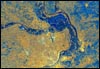
St. Louis appears in this radar image with downtown
St. Louis in the lower middle, colored as light yellow,
just along and above the river. Across the river (to
the right) are the cities of East St. Louis and Cahokia. |
 |
Washington
DC
View of the Washington DC area, including the Potomac
River. At the middle right is Andrews Air Force Base,
the airbase where the Presidential plane, Air Force
1 is usually based. |
 |
New York
City
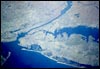
View from the Space Shuttle of New York City, the Hudson
River, and Long Island. Central Park in Manhattan can
be seen as a narrow rectangle. The bridge at the lower
left connects Brooklyn to Staten Island and is called
the Verrazano Narrows Bridge. |
 |
New
York City and Long Island
View of New York City and Long Island. |
 |
Boston
and Cambridge, Massachusetts
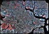
View of Boston, Cambridge, and the surrounding area,
with downtown Boston at lower right. The Charles River
flows from left to right. Vegetation is colored red
and the Boston Common (a large park) is seen in the
lower right. |
 |
Cape Cod,
Massachusetts
Cape Cod, Massachusetts, south of Boston. |
Page 3 of 4
|
|
|