The
following are
more images of the Earth taken by astronauts and satellites,
which can be used to supplement the
activity journey to the Sun. There are images of Chicago,
Denver, Atlanta, Boston, Puerto Rico, Washington DC,
New York City, St. Louis, Kansas City, and the Great
Lakes. They can be used to examine land patterns and
start a discussion about urban and rural areas. Some of
the pictures were taken by the Space Shuttle. Others were
taken by satellites mapping the Earth. A few, such as the
ones of Sacramento, California and St. Louis, were taken
with the SIR-C (Shuttle Imaging Radar) instrument,
which uses radio waves that can penetrate clouds to map
the surface of the Earth. The images of the Earth and
Moon were taken by the Clementine spacecraft.
Some Earth observing satellites can take images with a
resolution of about a meter. The images taken from these
satellites can easily distinguish a car from a bus, and a
house from a mobile home. The pictures provided here
have much poorer resolution. It might be interesting to
ask students to try to decide the size of the smallest
features on one of the images provided. Atlases or
roadmaps might be useful to do comparisons with the
images. Another interesting exercise is to try to decide
the time of day and time of year that an image was
taken, using only the image, and looking for shadows,
changes in vegetation, etc. Some of the images are
shown in false color. False color means that the images
have been colorized to emphasize certain information in
the image.
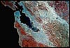 |
San Francisco Bay Area
Some of the features that can be seen are Golden Gate
Park, Alcatraz Island, and Treasure Island. The San
Andreas Rift Zone can be seen as the line separating
red and bluish green areas at the left side of the
image. |
 |
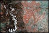
Sacramento, California, from Radar Imaging
The deep water ship canal is the line starting at the
bottom of the image. The dark triangle on the canal
is the Port of Sacramento. The Sacramento River can
be seen running down to the upper left and lower
right. This picture was taken using imaging radar. |
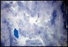 |
Walker
Lake, Nevada
The arid region of western Nevada as seen from a photograph taken by the Space
Shuttle. |
 |
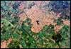
Denver,
Colorado, Rocky Mountains
This is a view of Denver and the Front Range of the Rocky Mountains in Colorado.
Note the South Platte River running through Denver. Small dark areas are lakes
and reservoirs. |
Page 1 of 4
|
|
|