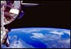
 |
Denver
from the Space Shuttle
The view is looking south at Denver, with the Front Range at the upper right
portion of the picture. |
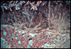 |
Colorado
View of Colorado showing agricultural areas colored red. Most of this agriculture
is made possible by center pivot irrigation systems, which use water from the
underlying Ogallala aquifer, which runs from Texas to South Dakota. |
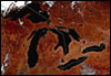 |
Great
Lakes
View of the Great Lakes in the northern US and southern Canada, with drawn lines
for state and provincial boundaries. Ships can navigate from the mouth of the
St. Lawrence river seaway to Duluth, Minnesota, on the western edge of Lake Superior,
a distance of 2,342 miles. |
 |
Chicago
and Surrounding Cities
Picture taken from the Space Shuttle of Chicago and surrounding cities. The Navy
Pier can be seen projecting from central Chicago. |
 |
Chicago
Area
A different, larger, view of the Chicago area, with vegetation represented as
red-colored areas. |
 |
Lake Michigan
View from the Shuttle of Lake Michigan, centered on
the Chicago area. |
 |
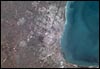
Kansas City
and Independence
View of the Kansas City and Independence, Missouri
area. The Kansas City airport can be seen at the middle
upper portion of the image, with the runway clearly
visible. Downtown Kansas City is at the center, next
to the river. |
Page 2 of 4
|
|
|