 Ice
On Venus? Home Teacher's
Page Table of Contents
Ice
On Venus? Home Teacher's
Page Table of Contents
|
Ice
On Venus? Home Teacher's
Page Table of Contents
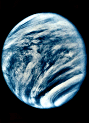
A view of the surface of Venus was long denied us Earthlings. Aside from being far away, it is enshrouded in a dense atmosphere with clouds that completely obscure our view of the surface. This was one good reason for us to send the Magellan spacecraft there (launched May 4, 1989).
Magellan was equipped with a radar transmitter/receiver that sent microwave pulses right through the clouds of Venus. The pulses bounced off the surface of Venus and returned to the radar receiver on Magellan. The time it took the pulse to leave Magellan, bounce off Venus and return to Magellan was very accurately measured. From that time measurement, Venus researchers could determine the precise distance to Venus and so determine altitudes of surface features to within 30 meters.
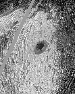 This is an image of a mountain
on Venus, Maxwell Montes. The image was created by the radar imaging method described
in the previous paragraph. Based on what you have found out about Venus so far, especially
considering its surface temperature, do you think the white areas could actually
be water ice? If not, what might the white areas be? Some other kind of ice? What
other kinds of ice might there be that could exist on Venus?
This is an image of a mountain
on Venus, Maxwell Montes. The image was created by the radar imaging method described
in the previous paragraph. Based on what you have found out about Venus so far, especially
considering its surface temperature, do you think the white areas could actually
be water ice? If not, what might the white areas be? Some other kind of ice? What
other kinds of ice might there be that could exist on Venus?
Jot down a few ideas that you have as answers to these questions--for class discussion.
Looking at images produced by radar can be deceiving. The image you are looking at is NOT like a normal photograph created with visible light--it is constructed from radar distance data.
Brightness variations in radar images result primarily from three different effects: (1) topographic effects (shape of the surface), (2) roughness, and (3) electrical properties of the ground. The details in the image can vary depending on the angle or the direction of the radar pulses. If you are interested in more about interpreting radar images, see the Guide to interpreting radar images.
Now, look for more of these "white areas" in Magellan images of Venus by visiting the NASA sites below.
First get a Venus map from your teacher so that you can write down on paper the places you find, specifying latitude and longitude and names of nearby features, if possible.
Please remember that the images you look at are not made from visible light, but interpretations of radar data. For this reason, not all white areas are "ice" of any sort.
NASA sites where you may find images of Venus:
Clickable Venus Map (more advanced interface--for older students and fast computers...)
![]()
 |
 |
Please send questions or suggestions to:
SEGway outreach:
outreach@ssl.berkeley.edu
Lawrence Hall of Science Home
Copyright © 1997 Regents of the University of
California
Updated
August 02, 2000