Find That Planet! Home | Next
Celestial Coordinates
 |
To find where an object like a planet is in the sky, we need to use a star map. You can make starmaps for your location and time at Your Sky. But to find a planet's position at any chosen time (not necessarily the current month) we can find out the planet's CELESTIAL COORDINATES and plot its position on our own star map that we create ourselves. |
Find out more by browsing the information below. Choose the first thing that seems new to you.
|
1. Latitude |
2. Longitude |
|
|
4. Declination |
6. Distance |
|
|
Sky & Telescope article on celestial coordinates: http://skytonight.com/howto/basics/3305886.html |
||
So Celestial Coordinates are to the sky, as geographical coordinates (latitude and longitude) are to the Earth.
Review of Geographical Coordinates
 The Earth's
spin determines certain special locations on the Earth. The spin axis goes through the North and South Poles,
and midway between them, the equator circles the Earth.
The Earth's
spin determines certain special locations on the Earth. The spin axis goes through the North and South Poles,
and midway between them, the equator circles the Earth.
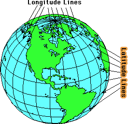
1. Latitude
To indicate how far north or south we are on Earth, we specify location in degrees of latitude.
What's the latitude of the North Pole? Of the equator? If you answered 90 degrees North for the North Pole and 0 degrees for the equator, that means you have a basic understanding of latitude. The latitude lines are all parallel lines running east to west and they are numbered from 0 to 90 degrees increasing from the equator to the North Pole (0 to -90 degrees towards the South Pole). You cannot see latitude lines on the ground--they are just a way of measuring how far north or south of the equator something is.
2. Longitude
 To indicate how
far east or west something is, you specify longitude in degrees. Longitude lines run perpendicular to the latitude
lines. Unlike latitude, where there is a unique zero place (the equator) determined by the spinning of the Earth,
there is no unique longitude determined by the spinning Earth. All longitude lines, which extend all the way from
the North Pole to the South Pole, are pretty much alike and they all swing by under the Sun in a 24 hour day. A
zero longitude was arbitrarily chosen to be the longitude line that runs through Greenwich, England. Unlike latitude,
which runs from 0 to 90 degrees north and 0 to 90 degrees south, longitude lines can be numbered in a complete
circle of 360 degrees, but we usually extend them only 180 degrees east of Greenwich and 180 degrees west of Greenwich.
To indicate how
far east or west something is, you specify longitude in degrees. Longitude lines run perpendicular to the latitude
lines. Unlike latitude, where there is a unique zero place (the equator) determined by the spinning of the Earth,
there is no unique longitude determined by the spinning Earth. All longitude lines, which extend all the way from
the North Pole to the South Pole, are pretty much alike and they all swing by under the Sun in a 24 hour day. A
zero longitude was arbitrarily chosen to be the longitude line that runs through Greenwich, England. Unlike latitude,
which runs from 0 to 90 degrees north and 0 to 90 degrees south, longitude lines can be numbered in a complete
circle of 360 degrees, but we usually extend them only 180 degrees east of Greenwich and 180 degrees west of Greenwich.
3. Minutes and seconds of arc
Aren't minutes and seconds just for telling time? NO! For giving locations more precisely, degrees of latitude or longitude are subdivided into minutes--each degree has 60 minutes. They are often called minutes of arc, because they measure an angle, just like degrees. Each minute is further divided into 60 seconds of arc.
So any where on Earth can be located by specifying its geographic coordinates in latitude and longitude. For example, San Francisco, California is 122 degrees, 26 minutes west of Greenwich and 37 degrees 46 minutes north of the equator. This is abbreviated
122 deg. 26' W
37 deg. 46' N
The single quote (') stands for minutes of arc, either latitude or longitude; A double quote mark (") stands for seconds of arc.
Celestial Coordinates
4. Declination
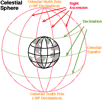 Imagine extending
the Earth's axis infinitely into space, north and south. Long ago, people believed that there was a giant sphere
to which the stars were attached--the celestial sphere. The Earth's axis would pierce that sphere in two
places: the celestial north pole and the celestial south pole. If you imagine the surface of the
Earth being inflated like a giant balloon until it touched the celestial sphere, the Earth's equator would be touching
the celestial equator.
Imagine extending
the Earth's axis infinitely into space, north and south. Long ago, people believed that there was a giant sphere
to which the stars were attached--the celestial sphere. The Earth's axis would pierce that sphere in two
places: the celestial north pole and the celestial south pole. If you imagine the surface of the
Earth being inflated like a giant balloon until it touched the celestial sphere, the Earth's equator would be touching
the celestial equator.
Even though we know there is no physical sphere out there holding up the stars, it's still convenient to think of an imaginary celestial sphere for specifying locations of things in the sky. The "celestial latitude lines" represent celestial coordinate known as declination. Just as latitude on Earth increases from 0 to 90 degrees as you move from equator to Pole, declination in the sky increases from 0 to 90 degrees as you look progressively north from the celestial equator, and from 0 to -90 degrees as you look progressively south from the celestial equator.
5. Right Ascension
Yup, you guessed it. There is something in the sky corresponding to longitude on Earth. The corresponding coordinate in the sky is called right ascension. Unlike longitude, which is measured in degrees and minutes, right ascension is measured in hours and minutes. There are 24 hours of right ascension corresponding to the full sweep of 360 degrees around the celestial equator. Simple division will tell you that each hour of right ascension must be equivalent to 15 degrees of arc.
Celestial coordinates specify which direction something is with respect to Earth, but not the distance to the object. For objects within the solar system (comets, planets, moons, asteroids), distance is often specified in Astronomical Units (AU)--an AU is the average distance from the Earth to the Sun = 149,597,870 kilometers (92,955,730 miles). For objects outside the solar system, the light year (ly) is often used. This is the distance light travels in a year, One light year is equal to 63,240 AU.
|
Find That Planet! |
Next: Get An Ephemeris |
Mail questions or comments: outreach@ssl.berkeley.edu
Copyright © 1996-2001 by Regents
of the University of California