Your answer was icy coastal islands.
 people have
made the same choice. A series of small islands is what it looks like. Islands
in beautiful, deep, blue water reflecting back white clouds. However, LANDSAT
does not "see" deep water in the color blue but in the color black.
people have
made the same choice. A series of small islands is what it looks like. Islands
in beautiful, deep, blue water reflecting back white clouds. However, LANDSAT
does not "see" deep water in the color blue but in the color black.
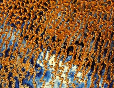
The answer is a desert depression. The image you're studying is part of the Rub al Khali desert in Saudi Arabia and Oman in the Middle East. It is so dry and the sand so soft that hardly anything - not plant, not animal, not human - lives there.
The picture may look wet to you but the truth is that this part of the Rub al Khali is like a huge sink and catches any water in the area and keeps it. There isn't really much water anyway and, certainly, not enough to form a beautiful lake. What the water makes is a type of muddy sand. LANDSAT images are colored bright blue where the ground is damp. The white areas were once muddy sand but were dry when the LANDSAT took this picture.
|
|
|
|
| Geographic Features | Main Menu | SEGway Home |


© Copyright 1995-2001Regents of the University of California and Exploratorium